


Descripción de FishTrack - Fishing Charts
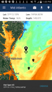
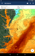
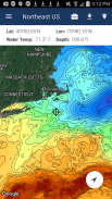
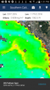
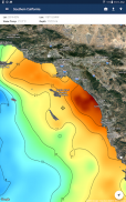
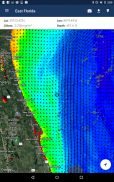
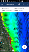
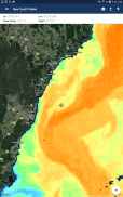
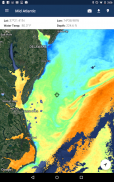
FishTrack provides saltwater anglers with everything they need to find fish. The FishTrack app offers free cloudfree sea surface temperature (SST) charts, global satellite imagery and marine weather forecasts – all in one layered tool.
With FishTrack you can:
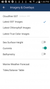
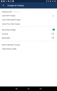
- View the latest SST, chlorophyll and true color satellite imagery
- Overlay bathymetry, ocean currents and sea surface height
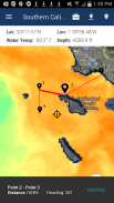
- Save waypoints to mark fishing spots and catches
- Create routes to plan a trip and view distances and headings
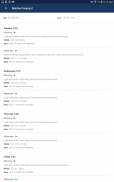
- View marine weather forecasts and tides/solunar tables
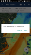
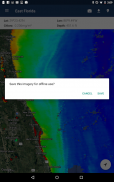
- Save fishing chart imagery for offline use
- View your current location both online and offline
Don't fish blind! FishTrack helps you plan a productive trip offshore. Burn less fuel and find fish faster.
We want to hear from you! Submit your questions or comments through our app to let us know what you think. If you'd like to speak directly with our customer service team, please e-mail us at: support@fishtrack.com.
FishTrack proporciona pescadores de agua salada con todo lo que necesitan para encontrar peces. La aplicación ofrece gráficos gratuitos FishTrack cloudfree temperatura superficial del mar (TSM), imágenes de satélite mundial y las previsiones meteorológicas marinas - todo en una herramienta de capas.
Con FishTrack puede:
- Ver último TSM, clorofila y verdadero de imágenes en color vía satélite
- Superposición de batimetría, las corrientes oceánicas y la altura de la superficie del mar
- Guardar waypoints para marcar lugares de pesca y las capturas
- Crear rutas de planificar un viaje y ver las distancias y las partidas
- Ver previsiones meteorológicas marinas y las mareas / tablas solunares
- Guardar las imágenes carta de pesca para uso sin conexión
- Visualización de la ubicación actual, tanto en línea como fuera de línea
No pez ciego! FishTrack le ayuda a planificar un viaje productivo en alta mar. Quemar menos combustible y encontrar los peces más rápido.
¡Queremos escuchar de ti! Envíe sus preguntas o comentarios a través de nuestra aplicación para hacernos saber lo que piensa. Si desea hablar directamente con nuestro servicio de atención al cliente, por favor envíe un correo electrónico a: support@fishtrack.com.
FishTrack provides saltwater anglers with everything they need to find fish. The FishTrack app offers free cloudfree sea surface temperature (SST) charts, global satellite imagery and marine weather forecasts – all in one layered tool.
With FishTrack you can:
- View the latest SST, chlorophyll and true color satellite imagery
- Overlay bathymetry, ocean currents and sea surface height
- Save waypoints to mark fishing spots and catches
- Create routes to plan a trip and view distances and headings
- View marine weather forecasts and tides/solunar tables
- Save fishing chart imagery for offline use
- View your current location both online and offline
Don't fish blind! FishTrack helps you plan a productive trip offshore. Burn less fuel and find fish faster.
We want to hear from you! Submit your questions or comments through our app to let us know what you think. If you'd like to speak directly with our customer service team, please e-mail us at: support@fishtrack.com.
FishTrack - Fishing Charts - Versión 1.3.1
(19-01-2024)
FishTrack - Fishing Charts - Información de APK
Version de la app: 1.3.1Paquete: com.fishtrack.androidApps en la misma categoría
Quizá también te interese...


